Sunday, March 9, 2014

Dade Battlefield State Park Bushnell, Florida Southwest Region

Date of visit:  Sunday March 9, 2014

Got to here while picking up the coach in Wildwood, about 25 miles away-  


Welcome to Dade Battlefield Historic State Park

Every January, under the oaks of Dade Battlefield State Park, history lovers gather to commemorate the battle that started the Second Seminole War. On December 28, 1835, Indian warriors ambushed 108 U.S. soldiers at this site, and only three soldiers survived. The 80-acre park protects not only a historic battlefield, but also the natural communities as they existed during the war. As you stroll the half-mile trail through pine flat-woods, keep your eyes peeled for gopher tortoises, woodpeckers, songbirds, hawks or indigo snakes. The amenities of Dade Battlefield include a playground, picnic area with covered shelters and recreation hall. The park's visitor center provides information and displays about the historic battle, as well as a 12 minute video history of the battle This Land, These Men.


History and Culture
When Florida became a U.S. territory and settlers began moving here, the Native Americans were forced to move south. By the 1830s, significant conflict had arisen between Seminoles and white settlers. The Seminole practice of giving refuge to fugitive slaves added further cause for conflict. With the signing of the treaty of Payne's Landing in 1832, some chiefs agreed to move to territory west of the Mississippi River. Widespread opposition to this treaty, led by a Seminole chief named Osceola, resulted in the outbreak of the Second Seminole War. In December 1835, 108 U.S. troops and officers were marching from Fort Brooke (Tampa) to reinforce Fort King (Ocala). One hundred miles from Fort Brooke, they were attacked by 180 Seminole warriors. All but three of the soldiers were killed. In 1921, the state legislature appropriated funds for the preservation of the battle site as a memorial.
Large oaks canopy the battlefield in this 1940s photograph.
Battlefield c1940
The Dade Battlefield Historic State Park commemorates the 1835 battle which began the Second Seminole War, the longest and bloodiest of the three Seminole Wars in Florida. In the early 1920s, the state of Florida acquired the site to preserve the battlefield and provide opportunities for interpretation and quiet reflection. This photograph, taken in the 1940s, shows the battlefield as it appeared from the 1920s until the 1950s when statuary, such as the pelican shown in the photograph, was removed to provide a more historically accurate view of the battlefield.
A stone and concrete monument on the battlefield commemorates Captain Fraser, one of three officers killed in the battle which occurred there.
Captain Fraser Monument
Three concrete and stone markers, constructed in the 1920s, commemorate the three U.S. officers killed in the battle: Major Dade, Captain Fraser and Lieutenant Mudge. The monuments are located in the approximate location where each of these men fell.
A historic stone and concrete bandstand awaits to provide a shady spot for park visitors.
Bandstand
This historic bandstand reflects the recreational use of a earlier era. It is now a popular place for weddings and family reunions.
This photograph shows the park's recreation building shortly after its completion in 1957.
Recreation Building, 1957
The recreation building was one of several buildings built in the park in the late 1950s to provide additional opportunities for recreation and interpretation in the park. This photograph shows the building shortly after its completion in 1957.
This photograph of the recreation building shows the recreation building as it appeared in 2007.
Recreation Building, 2007
This photograph, taken in 2007, shows how little the recreation building and its surrounding landscape has changed in 50 years. The building continues to be one of the most used buildings in the park for both educational and recreational purposes.

Silver Springs (or Silver River, if you prefer... they are a little behind on the name change) Ocala Florida

Date of visit-  Sunday, March 9 2014.  

Hit this park on the way down to Wildwood to pick up the coach. 


Silver Springs State Park


This Park has more than 15 distinct natural communities, dozens of springs and miles of trails.


On the River side: Visitors can canoe down the crystal clear river ( there is no fee to launch on this side but there is a ½ mile hike to launch area), hike or bike along one of the nature trails, or just sit and watch for the wide variety of birds and wildlife.

The picnic area features three pavilions with grills that may be rented for group outings and a playground for the youngsters.

For overnight stays, the River side has a full facility campground and 10 luxury cabins.  There is also a primitive campground for use by organized groups (scouts, church groups, etc.)

The River side of the park is home to a pioneer cracker village and the Silver River Museum and Environmental Education Center. The center is operated by the Marion County School District in cooperation with the park and is open to the public on weekends and holidays from 9:00 a.m. to 5:00. p.m. Admission to the Museum is $2.00 per person. Children under 6 are free. For more information please visit Silver River Museum

On the Spring side:  Visitors can view the spring head from a covered viewing deck, walk along the river on the paved trails and see the ornamental gardens and Spring head.  Glass bottom boat rides are offered for $9.99 + tax per person and run on the hour daily from 10 AM until 4 PM.  Our concessionaire offers food at the Spring Side Restaurant 10 AM until 4:30 PM daily.  There is a canoe and kayak launch located at the South East corner of the main parking lot. Rent a canoe or kayak at the park from 9 AM to 3:00 PM or bring your own. There is not a shuttle at this time for pick up and drop off at other locations. There is a $4.00 per boat launch fee if you bring your own canoe or kayak.  There is no land access from the water at all along the river and in the spring head area unless you enter from the parking lot and use the boat launch to access land, fees apply. 

There are two entrances to Silver Springs State Park. The entrance to the Spring Side is located on State Road 40 at 5656 E Silver Springs Blvd, Silver Springs, Florida 34488 and the entrance to the River side is located on State Road 35 at 1425 NE 58th Avenue, Ocala Fl 34470.

History and Culture
In the 1820s, the springs became a tourist attraction for adventurous visitors who poled their way along the narrow stream through overhanging cypress and Spanish moss. With the invention of the paddlewheel, Silver River and Springs became a distribution center for Central Florida. Plantations growing vegetables, tobacco and oranges sprang up along the banks as nearby Ocala grew. In the late 1870s, Phillip Morrell fixed a piece of glass in the bottom of a rowboat and a new enterprise began. Silver River's glass-bottom boat tours have been world famous for more than over 100 years.
Birds gather under the moss-covered trees along the Silver River in this historic postcard view.
Early View of River
This early view of the Silver River shows what has attracted people to the area for thousands of years: abundant water, wildlife and beautiful scenery.
The Silver River State Park and Silver River Museum and Environmental Education Center  signs mark the entrance to the park.
Entrance Signs
The Silver River Museum and Environmental Center and Silver Springs State Park both opened to the public in 1987. For several years, however, the Silver River Museum and Education Center was the only developed area at the park. The continued relationship with the park and the Marion County School Board has given many local school children the opportunity to participate in environmental education programs at the Center.
This tin-roofed  wood framed house is one of several historic structures on display at the Cracker Village.
Cracker House
The Cracker Village at the Silver River Museum and Education Center consists of a reconstructed Cracker house and several other structures representing the life of early pioneers in Central Florida.
The entrance station welcomes visitors to Silver River State Park.
Entrance Station
The entrance station, completed in 2000, was one of the first park buildings constructed at Silver Springs. Since that time, a campground, cabins, picnic area with playground and a canoe and kayak launch have been added, providing additional recreational opportunities for park visitors.
Two men dressed as early Florida settlers or 'crackers' relax by a campfire during the annual Ocali Country Days event.
Country Days
The Ocali Country Days is one of several special events held regularly at the park and the museum and education center. The Ocali Country Days is an annual two-day event honoring Central Florida's history. Here two men dressed as Florida 'crackers' relax near a campfire in the Cracker Village

Thursday, February 20, 2014

Fort George Island State Park- Jacksonville Duvall County Northeast District


Regional Map of Florida
Map of Fort George Island Cultural State Park
Southeast Region Southwest Region Central Region Northeast Region Northwest Region


                    Large white two story building with landscaping is home to the Ribault Club located at Fort George Island Cultural State Park.

                   Welcome to Fort George Island Cultural State Park

Native Americans feasted here, colonists built a fort, and the Smart Set of the 1920s came for vacations. A site of human occupation for over 5,000 years, Fort George Island was named for a 1736 fort built to defend the southern flank of Georgia when it was a colony. Today´s visitors come for boating, fishing, off-road bicycling, and hiking. A key attraction is the restored Ribault Club. Once an exclusive resort, it is now a visitor center with meeting space available for special functions. Behind the club, small boats, canoes, and kayaks can be launched on the tidal waters.


Map showing the location of Fort George Island Cultural State Park
LocationDuval County, Florida, USA
Nearest cityJacksonville, Florida
Coordinates30°25′34″N 81°25′55″W / 30.42611°N 81.43194°W / 30.42611; -81.43194Coordinates: 30°25′34″N 81°25′55″W / 30.42611°N 81.43194°W / 30.42611; -81.43194
Established1989
Governing bodyFlorida Department of Environmental Protection
Tabby ruins
Ribault Inn Club, a winter resort now used as visitor's center
Fort George Island State Cultural Site is a Florida State Park located on Fort George Island, about three miles (5 km) south of Little Talbot Island State Park on SR A1A. It is home to the Ribault Inn Club, constructed in 1928 as a winter resort and now used as a visitor's center.[1] The 46,000-acre (190 km2) Timucuan Ecological and Historic Preserve, in Jacksonville, Florida is nearby. Fort George has the highest point along the Atlantic coast south of Sandy Hook, New Jersey, and contains Timucua oyster shell mounds. The park is part of the Talbot Islands GEOpark complex.
The park contains several distinct periods in human history. During the early historical period Fort George Island was known as Alicamani. It was the location of the village of Alicamani, a major village of the Timucua chiefdom known as the Saturiwa. Timucua influence is noted by the presence of middens, large mounds that are compiled of massive middens or shell mounds filled with discarded food byproducts. On Fort George Island, the shells were primarily oysters. The island was later home to the Spanish mission of San Juan del Puerto, the primary mission to the Saturiwa.
Under British rule in 1765, colonists developed a plantation on the island. It is now known as Kingsley Plantation, after Zephaniah Kingsley, who held it for 25 years. The main house, kitchen and numerous slave quarters have survived.
Activities include off-road bicycling, hiking, boating, canoeing, kayaking, and fishing. Amenities include a 4.4-mile (7.1 km)-long loop bicycle trail, boat ramp, a 3-mile (4.8 km) hiking/biking trail, and a beach. The park is open from 8:00 am till sundown year round.


Tuesday, February 18, 2014

Bill Baggs/Cape Florida State Park - Southeast Region Key Biscayne, Florida

Date Visited:  Tuesday,, February 18, 2014


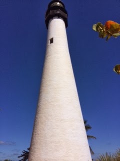
I combined this with two other Metro Miami stops today-  The park is located at the very end of Key Biscayne, and is quite large.  The highlight other than a terrific beach is the Cape Florida Lighthouse, and I was able to walk the grounds, but the lighthouse was closed today.